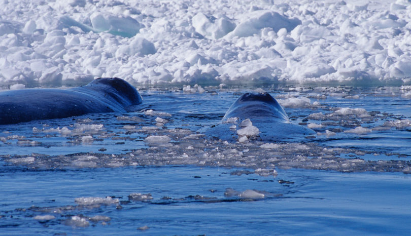
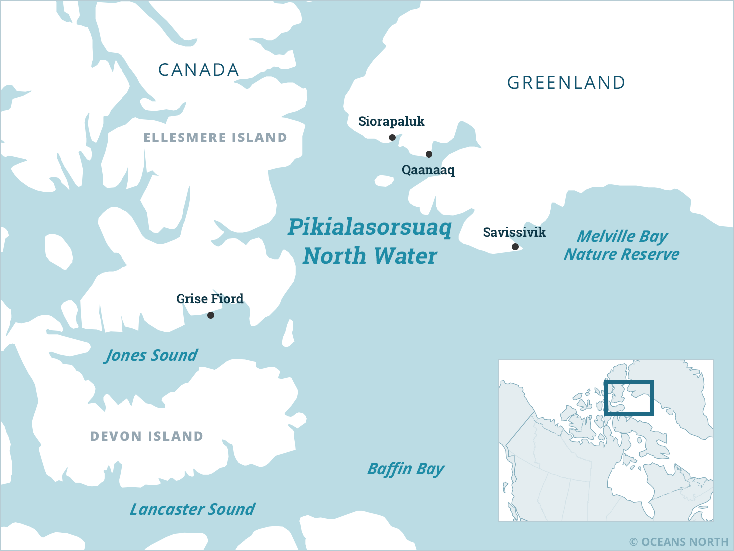
The North Water Polynya, called Sarvarjuaq in Inuktitut and Pikialasorsuaq in Greenlandic, is one of the planet’s most productive ocean ecosystems. An open-water area surrounded by ice in northern Baffin Bay, it supports an abundance of marine mammals, including narwhal, walrus, seals and polar bears, as well as seabirds and a variety of fish. Covering about 85,000 square kilometres, the Arctic’s largest polynya provides crucial habitat during annual migrations.

The Great Upwelling

Each spring, the proliferation of new life in Sarvarjuaq / Pikialasorsuaq (which means the “Great Upwelling”) supports the rich biological diversity in other parts of the Arctic as well. Arctic cod, seabirds and marine mammals migrate from the polynya to Melville Bay and Lancaster Sound, the eastern gateway to the Northwest Passage, and beyond.

What Is a Polynya?

A polynya is an area of year-round open water surrounded by heavier, thicker sea ice cover. Polynyas are marine oases in the Arctic, their nutrient-rich waters providing a place to feed, mate and overwinter for a wide range of species.

The North Water Polynya is fed by freshwater from melting ice caps in Greenland and Canada that mix with Pacific water columns snaking through underwater channels in the Northwest Passage and Lancaster Sound. These icy waters merge with a warmer Atlantic current and are carried up the west coast of Greenland.

The existence of the North Water Polynya is dependent on cold, stable winters that form an ice bridge between Canada’s Ellesmere Island and Greenland. This ice bridge prevents polar pack ice from flooding into the polynya. Prevailing north winds push any ice that forms in the polynya to the south, helping to keep it clear.

When the sun returns to the High Arctic in late winter, a spectacular biological phenomenon takes place in the North Water. The combination of sun and open water — scarce commodities in an otherwise frozen ocean — mean that solar energy can be absorbed and distributed through photosynthesis. This creates the annual plankton explosion. Phytoplankton transform solar energy into a food source for species higher up the food chain. Fish, seabirds and marine mammals all depend upon this spring plankton bloom.

People of the North Water

The ice bridge between Ellesmere Island and Northwest Greenland that helped create the North Water Polynya has been an Inuit migration route for centuries. Qidtlarssuaq, a 19th-century shaman and Inuit leader, traveled with his followers from what is now Nunavut across the ice bridge to the Qaanaaq Region of Greenland. He is credited with reintroducing lost technologies, including the qajaq (kayak) to the people there.

Inuit communities on both sides of Baffin Bay rely on the North Water Polynya’s natural wealth, hunting and harvesting wildlife and fish. Communities located near the polynya, such as Grise Fjord and Qaanaaq, as well as villages that are hundreds and even thousands of kilometres away, benefit from species that migrate through this region. This shared reliance on the north water has created important cultural linkages between Nunavut and Greenland.

Changing Sea Ice Conditions

The North Water Polynya is dependent on consistent ice conditions. On several occasions over the last few decades, the ice bridge in Nares Strait has failed to form in the winter, causing sea ice from the High Arctic to drift south and fill the polynya. As the Arctic warms due to climate change, sea ice has become thinner and more variable, and the future of the ice bridge is uncertain. These changes have consequences for the flora and fauna dependent on the polynya, as well as for the people of Sarvarjuaq / Pikialasorsuaq who rely on its rich biological productivity.

The best way to understand these changing ice conditions is to examine trends over time. The satellite images above, provided by Bremen University in Germany, show weekly glimpses of the North Water Polynya. These photos can be compared with images from previous weeks or years to track the formation of the polynya’s ice bridge each winter and how it breaks down each spring. By using this technique, researchers have established that the number of days the ice bridge is in existence has decreased by about 2.1 days annually over the last 40 years – or 84 days in total – with considerable variation between seasons.

The two time lapse videos below highlight the vast variations between where, and for how long, the ice bridge has formed in Nares Strait during winter seasons. The edge of the ice bridge is commonly seen in the southern portion of Nares Strait (e.g. time lapse of 2015-2016), and lasts an average of 141.7 days. On occasion, the ice bridge in Nares Strait doesn’t fully form. The winter of 2007 was one example of this. And in the winter of 2018-2019, the ice arch appeared to form briefly but actually allowed sea-ice to flow south.

The Pikialasorsuaq Commission

In 2013, the Inuit Circumpolar Council Greenland met in Nuuk, Greenland, with community members from around Pikialasorsuaq to share their concerns about the future of this region. As a result, the Pikialasorsuaq Commission was created in 2016. Its mandate was to facilitate community and regional input, to incorporate Indigenous knowledge and to recommend strategies for safeguarding and monitoring the health of the Pikialasorsuaq for future generations.

Three commissioners were appointed: an international representative, one from Canada and one from Greenland:

  • Okalik Eegeesiak, chair of the Inuit Circumpolar Council
  • Eva Aariak, former premier of Nunavut
  • Kuupik Kleist, former Greenland premier

A Shared Future

Oceans North supported the establishment of the Pikialasorsuaq Commission and assisted with its consultations in both Nunavut and Greenland. During those meetings, Inuit on both sides of Baffin Bay called for the creation of a cooperative caretaking body for Pikialasorsuaq, led by local residents. The commission explored ways that Inuit from both countries can work together to monitor and manage this rich ecosystem and released a report with recommendations in 2017.

In December 2018, the Pikialasorsuaq Commission finished its work and was replaced by the Pikialasorsuaq Implementation Committee (PIC). The purpose of the PIC is to implement the commission’s recommendations, assist in the development of an Inuit-led management regime of this region and to support negotiations between regional and national governments.

In Canada, the North Water Polynya has been identified by some leaders and community members as a possible site for an Indigenous Protected Area. Greenland is a self-governing country within the Kingdom of Denmark that currently retains authority for most decisions related to its offshore waters. A Canada-Greenland co-management body for the North Water Polynya, which Oceans North supports, could advance Denmark and Greenland’s shared goal of expanding self-governance and promoting Greenland’s autonomy over its natural resources.

Related Resources

People of the Ice Bridge The Future of the Pikialasorsuaq

Pikialasorsuaq is the largest Arctic polynya and most biologically productive region north of the Arctic Circle. The Pikialasorsuaq Commission, made up of representatives from both sides of Baffin Bay, issued this report in 2017 with major recommendations for the conservation and management of the polynya.